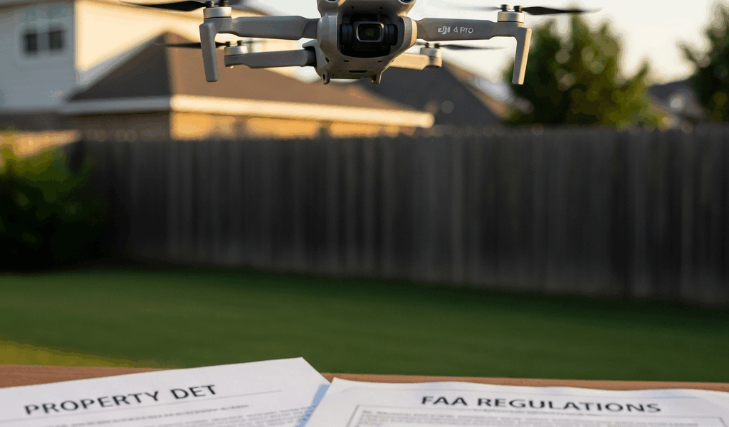
What the FAA Actually Controls Up There
Drone law has gotten complicated with all the misinformation flying around — and I mean that almost literally. The FAA owns the National Airspace System. Not you. Not your neighbor. The FAA.
As someone who spent three months flying a DJI Mini 4 Pro under a completely wrong assumption, I learned everything there is to know about this the hard way. Today, I will share it all with you.
My mistake was embarrassingly basic. I assumed the airspace above private property belonged to whoever owned the land underneath it. It doesn’t. The second your drone clears the ground, you’re operating in federal airspace — full stop. That distinction has real consequences, and ignoring it is how otherwise careful pilots end up in legal trouble.
But what is navigable airspace, exactly? In essence, it’s the federally controlled airspace that the FAA manages for aviation safety. But it’s much more than that. For drone operations, that airspace technically starts at the surface — not at 400 feet. The 400-foot ceiling in Part 107 and recreational rules is a hard limit, not a definition of where federal jurisdiction begins. That creates immediate friction between federal airspace law and state property rights.
The FAA handles flight operations, airspace authorization, safety compliance. Full stop. Privacy complaints, trespass claims, surveillance disputes — none of that falls under the FAA’s umbrella. That’s where state and local law takes over entirely.
Sub-250g Doesn’t Mean You Can Fly Anywhere
Probably should have opened with this section, honestly. It’s the single biggest misconception I run into.
The DJI Mini 4 Pro weighs 249 grams — just under the 250-gram threshold that triggers FAA registration requirements and Part 107 remote pilot certification. A lot of owners interpret that exemption as some kind of blanket freedom pass. It isn’t.
What the weight exemption actually eliminates: FAA drone registration and the Part 107 certificate for recreational use. That’s the complete list. Everything else still applies to you — and I mean everything.
You still need visual line of sight at all times. You still can’t fly over moving vehicles or people. Manned aircraft still have right-of-way, always. Night flights between dusk and dawn still require a waiver. Class B, C, D, and E airspace restrictions still bind you just as tightly. LAANC authorization still matters in controlled airspace. City ordinances banning drones in parks, near schools, or in residential zones? Still apply — regardless of what your drone weighs.
I’ve watched otherwise detail-oriented pilots check the weight spec, assume the rest would sort itself out, and end up in genuinely avoidable situations. Don’t make my mistake. The 249-gram figure is a narrow regulatory carve-out, not an all-clear signal.
When Flying Over Private Property Becomes a Problem
Three scenarios. Real pilots face all three of them eventually.
Drifting Over a Neighbor’s Backyard
You’re chasing golden-hour footage. The light is hitting the tree line perfectly. You pitch forward and your Mini 4 Pro drifts across your neighbor’s property at around 80 feet — maybe 15 seconds of total overlap — before you correct course.
From the FAA’s standpoint, nothing happened. You maintained visual line of sight, stayed under 400 feet, didn’t fly over people. Federal jurisdiction ends right there.
Your neighbor might see it differently. Several states treat that 80-foot pass as a trespass, depending on intent and duration. The old “ad coelum” doctrine — the idea that land ownership extends infinitely upward — has been eroded by aviation law, but courts have carved out plenty of room for drone-specific disputes. Texas Penal Code § 21.08, Florida Statute § 934.215, and North Carolina General Statute § 15A-300.1 all contain explicit drone privacy provisions. Criminal and civil liability is on the table under those statutes, regardless of FAA clearance. That’s not a hypothetical — it’s happened.
Crossing Adjacent Property to Reach a Filming Location
You’re shooting a real estate package for a 10-acre listing. The only clean launch point sits on a neighboring parcel whose owner hasn’t said yes or no. You fly a 50-meter arc over that property to position yourself correctly.
Frustrated by geography and a tight shoot window, you make the call and cross the line — using your best judgment and a verbal assumption that no one will care. That’s the scenario that generates insurance claims. The FAA has no objection to the flight path. The neighboring property owner, however, has a trespass argument under state law that doesn’t care what the FAA thinks. One-day commercial drone liability coverage runs $20 to $40 depending on the insurer. That’s not expensive. Not having it when this situation bites you absolutely is.
Hovering Near a Structure You Don’t Own
You’ve got a verbal green light from a site supervisor at an active commercial construction project. You hover your Mini 4 Pro about 30 feet from a partially framed roofline for roughly 30 seconds, capturing structural detail shots.
No FAA violation there. But if that supervisor lacked actual authority to grant you access, you’ve committed trespass — verbal permission from the wrong person doesn’t protect you legally. And if your hover pattern put you anywhere near active equipment or workers, you’ve potentially created a safety liability that has nothing to do with airspace regulations.
What Property Owners Can and Cannot Do
They cannot shoot it down. Full stop.
Firing at an aircraft in flight violates 18 U.S.C. § 32. That conviction carries up to 20 years in federal prison. The FAA and DOJ prosecute these cases — I’m apparently one of those people who reads federal prosecution summaries for fun, and this comes up more than you’d think. It is not a gray area.
Property owners also can’t demand you land based solely on the fact that you’re in the airspace above their land. They can’t deploy jamming equipment or signal blockers — that’s an FCC violation, not a gray area either. They can’t threaten police action purely because a drone exists somewhere above their property line.
What they can legitimately do is a different list. They can demand you stop capturing images or footage of their property — and you’re expected to comply. They can file trespass complaints if your flight pattern suggests intentional surveillance. Civil remedies — injunctions, damages, emotional distress claims — are available under state law if your conduct crosses the line.
Repeated hovering over the same property. Flight paths that track windows, patios, or outdoor living spaces. Timing that coincides with people being visibly present. These patterns create legal exposure for you, not for the person you’re flying over. Courts notice flight logs.
How to Actually Stay Out of Trouble With the Mini 4 Pro
While you won’t need a law degree, you will need a handful of basic habits to fly cleanly and keep yourself out of disputes.
First, you should download the FAA’s B4UFLY app — at least if you’re flying anywhere you haven’t already thoroughly checked. It cross-references your GPS location against active airspace restrictions, TFRs, and LAANC availability in real time. Free. Takes about 60 seconds per preflight check. No excuse to skip it.
B4UFLY might be the best option for quick airspace checks, as drone compliance requires location-specific data updated in real time. That is because airspace status changes — TFRs appear with very little notice, and flying into one is a federal violation that “I didn’t know” won’t dissolve.
Spend 15 minutes on drone law for any new state or county before your first flight there. Texas drone law and Florida drone law read very differently. North Carolina’s privacy statute is different still. This isn’t optional caution — it’s the minimum.
In residential areas, I keep my Mini 4 Pro between 100 and 150 feet even though the legal ceiling is 400. That’s not legally required. It’s just practical. Lower altitudes over houses are where complaints and confrontations originate.
Never hover directly over occupied structures, enclosed vehicles, or people without explicit permission. That one habit eliminates most of your privacy and trespass exposure before it starts.
For commercial work — real estate, construction documentation, inspections — document everything. Written property owner authorization. A written scope of work describing what you’re capturing and why. Flight logs showing altitude, duration, and GPS path. I’m apparently meticulous about this and it’s saved me twice in client disputes where word-of-mouth authorizations suddenly became contested.
That’s what makes this stuff endearing to us drone pilots — the gap between what’s technically legal and what’s genuinely smart is where most problems live. Good judgment beats legal technicalities every time. So, without further ado: fly respectfully, ask before you hover, document everything commercial, and treat the 400-foot ceiling as the ceiling it is — not as the floor of your rights.

Stay in the loop
Get the latest dronefaaregulations updates delivered to your inbox.