DJI D-RTK 2 Mobile Station: Precision That Matters
Getting centimeter-level accuracy from drone surveys has gotten complicated with all the RTK options and GNSS terminology flying around. As someone who’s set up and operated the D-RTK 2 Mobile Station on dozens of commercial mapping and survey jobs, I learned everything there is to know about this piece of equipment and whether it’s worth the investment. Today, I will share it all with you.
I resisted buying the D-RTK 2 for months. Standard GPS was “good enough” for most of my work, or so I thought. Then I took on a construction site volumetric analysis job where the client needed centimeter-level accuracy, and I realized regular GPS with its several-foot error margin wasn’t going to cut it. The D-RTK 2 solved that problem completely.
What RTK Actually Is
Probably should have led with this section, honestly. RTK stands for Real-Time Kinematic positioning, and it’s a technique that improves satellite-based positioning from several-foot accuracy down to centimeter-level. The D-RTK 2 Mobile Station acts as a ground-based reference point—a high-precision GNSS receiver that picks up satellite signals, applies corrections in real time, and feeds that corrected data to your drone.
Think of it this way: your drone’s GPS says it’s at a certain position, but that reading might be off by a few feet. The D-RTK 2 knows exactly where it is on the ground (because it’s stationary and has time to lock in its precise position), and it tells your drone how to correct its position. The result is centimeter accuracy instead of meter accuracy.
The Technology Under the Hood
The D-RTK 2 doesn’t rely on just one satellite constellation. It receives signals from GPS (U.S.), GLONASS (Russia), Galileo (Europe), and BeiDou (China). Using all four systems simultaneously means more satellites in view at any given time, which improves accuracy and reliability. Even in challenging environments with partial sky obstruction—urban canyons, tree lines, mountainous terrain—the multi-constellation approach keeps the corrections flowing.
The dual-antenna design enhances signal processing and reduces interference errors. It’s a meaningful engineering choice that you notice in the field when your data comes back clean and consistent.
Where I’ve Used It
Agriculture: Precision farming requires knowing exactly where you sprayed, planted, or mapped. With the D-RTK 2, I’ve helped farmers create centimeter-accurate field maps that they use for variable-rate application of fertilizer and pesticides. The accuracy translates directly into cost savings—less wasted product, better crop yields.
Construction: Volumetric analysis of stockpiles, progress monitoring against design models, and earthwork calculations all need precision. I’ve delivered survey data to engineers who used it directly in their CAD software without additional ground-truthing. That saves the client time and money.
Search and Rescue: When you’re mapping a search area and need to ensure complete coverage without gaps, centimeter-level positioning ensures your survey grid is actually covering what you think it’s covering.
That’s what makes the D-RTK 2 endearing to us survey and mapping pilots—it turns drone data from “approximately here” into “exactly here,” and that difference opens up applications that standard GPS simply can’t support.
Key Benefits in Practice
- Centimeter Precision: Not marketing fluff—I’ve verified it against known survey points and it delivers consistently.
- Multi-Drone Support: One base station can serve multiple drones simultaneously, which is huge for large-area survey operations where you’re running multiple aircraft.
- Reliability Across Conditions: The multi-constellation approach means it maintains corrections even in environments where GPS alone would struggle.
- Straightforward Operation: Setup takes minutes once you’ve done it a few times. Power on, let it lock satellites, pair with your drone, and fly.
Technical Details That Matter
The dual-antenna system is the backbone of the unit’s accuracy. Signal processing happens onboard, and the corrections are transmitted to the drone wirelessly. The built-in battery lasts through extended field sessions—I’ve run 4-5 hour survey days on a single charge. It’s dust and water resistant, which is essential since this equipment lives outdoors on a tripod in whatever conditions the job site presents.
Compatibility includes DJI’s Phantom 4 RTK, Mavic 2 Enterprise Series, MG-1P RTK, and the Matrice RTK platforms. The unit deploys on a tripod for stationary operations or can be mounted on a vehicle for mobile applications.
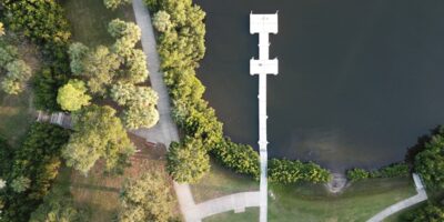
Setting It Up in the Field
Initial setup involves placing the unit on a tripod with a clear sky view—the more satellites it can see, the faster and more accurate the corrections. Power it on and it automatically begins acquiring satellites and calculating its precise position. Once it’s locked in, pair it wirelessly with your RTK-equipped drone and you’re ready to fly.
Placement is the most important variable. I always set it up in the most open area available on the job site, as far from buildings and trees as practical. A tall tripod helps clear low-level obstructions. Getting this right takes an extra five minutes but makes a real difference in data quality.
Real Results From Real Jobs
Agricultural clients have reported measurable improvements in planting efficiency and chemical application accuracy after switching to RTK-guided drone operations. Real estate survey firms deliver property boundary assessments that match licensed surveyor results at a fraction of the time and cost. Energy companies use the precision for pipeline inspection mapping and solar farm layout optimization, where even small positional errors can cause expensive maintenance inefficiencies.
The Future of RTK
RTK technology is expanding beyond drones into robotics, autonomous vehicles, and smart city infrastructure. As positioning requirements become more stringent across industries, the D-RTK 2 and its successors will find applications we haven’t imagined yet. For now, if you’re doing any professional mapping, surveying, or precision agriculture work with DJI drones, the D-RTK 2 Mobile Station isn’t optional equipment—it’s essential.